

Is the Dornoch Terrace road safety upgrade a waste of money?
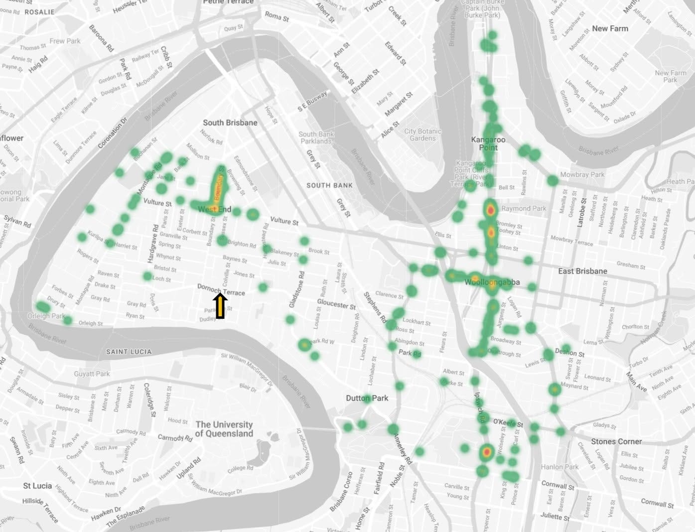
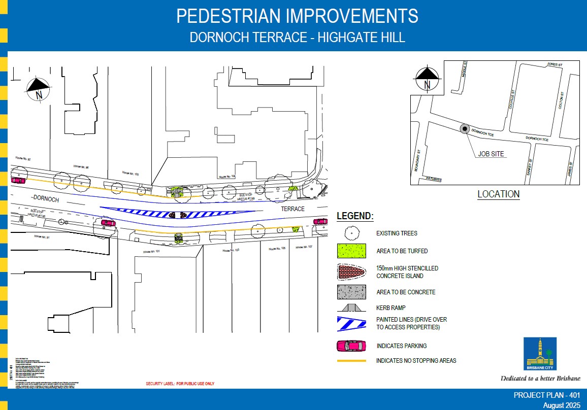
A pedestrian safety upgrade has been proposed for approximately 101 Dornoch Terrace in Highgate Hill. The project would install a new pedestrian crossing at an estimated cost of at least $80,000 and remove approximately 19 on-street parking spaces currently used by local residents, along with a street tree and associated road works.
Analysis of the Queensland Government’s open road crash dataset covering 2001–2024 indicates that there has been only one recorded pedestrian-involved crash on the entire length of Dornoch Terrace in 23 years. That incident occurred at the intersection of Dornoch Terrace and Hampstead Road, approximately 400 metres from the proposed crossing location.
Within a reasonable catchment area of the proposed crossing (±100 m, based on commonly cited pedestrian detour distances in urban design guidance), the dataset shows seven crashes since 2001 and zero pedestrian involvement.
The available data therefore does not indicate a concentration of pedestrian incidents at the proposed location. At the same time, the project imposes a clear loss of resident amenity through the removal of street parking and streetscape changes.
In addition, no clear explanation of the data, criteria, or methodology used to select this location has been provided publicly. The published material lists categories of information considered (e.g., counts, aerial imagery, cadastral data) but does not disclose the underlying data, thresholds, weighting, or alternative locations evaluated. No pedestrian counts or demand data have been publicly provided to support the need for a crossing at this location.
This analysis therefore raises three questions:
Whether the proposed location is supported by crash or safety data.
Whether the location was selected using a transparent and reproducible methodology.
Whether the benefits of the project outweigh the loss of resident amenity.
Background
Cr Trina Massey proposes to construct the Dornoch Terrace Pedestrian Crossing (the crossing) around 101 Dornoch Terrace.
This project encompasses:
Establishment of a new pedestrian road crossing for a minimum of $80,000.
Removal of 19 car spaces residents use for off-street parking, removal of a street tree, and other works.
This post argues that:
The area is poorly chosen.
Accident data shows zero pedestrian involvement in 23 years.
Dornoch Terrace has a high rate of accidents (134 in the base dataset – almost 6 per year) however there has been only a single pedestrian involvement across the entire length of the street in 23 years.
No evidence of rational planning for this crossing has been provided by Cr Massey’s office. The design process has been opaque. The consultation process, while compliant, is flawed.
In the absence of data, this planning looks arbitrary.
Throughout this post I will quote my sources of data and provide links to those.
I have also provided instructions for you to extract this data and put it into a usable format to replicate findings for yourself. You will need basic file / spreadsheet manipulation skills.
So you’re against pedestrian safety?
Of course not. Every member of the community has an interest in road safety.
A pedestrian safety upgrade is only effective if there is data to support that there is a pedestrian safety issue at the location. There isn’t. The money is better spent elsewhere.
Timeline and Consultation
The following is the timeline as best I understand it from discussing this project with people on the various local Facebook Groups and the data in Cr Massey’s blog post.
7 July 2025: Short mention in Cr Massey’s Winter Newsletter: https://assets.nationbuilder.com/southbrisbanegreens/pages/20984/attachments/original/1751932001/Trina_Massey_Winter_Newsletter_2025.pdf?1751932001
Prior to August 2025, design work my Cr Massey’s office. Source: August 2025 date stamp on Project 401 schematic on Cr Massey’s blog: https://assets.nationbuilder.com/southbrisbanegreens/pages/21645/attachments/original/1770250650/DornochTceConceptplan.jpg?1770250650
5 Feb 2026: First public plans published stating that the plans are approved. There is a poll for anyone in the ward to vote yes/no however no consultation was done at the design phase.
Why am I doing this?
I first learned about this project and the impacts when my wife drew my attention to a post early Feb 2026 regarding community consultation (https://www.facebook.com/crtrinamassey/posts/pfbid031wZxNkH3hWgJdGf9JTSdvkpwRcFn95gRAdkroUv22R9XMoPnkmVUnn4eCXusiaVQl).
I read Cr Massey’s post on the topic (https://www.trinamassey.com/dornoch_terrace_pedestrian_safety_upgrade) and was surprised by a few things in no particular order:
Location Selection: No actual information on the selection criteria, methodology or data were provided. Loss of local resident amenity by way of street parking removal.
Approved Prior to Consultation: The post lists the plans as fully approved.
I called 34038888 to speak with the civil project team for on the 11 Feb and was advised that they had no record of the project and no idea what “Project 401” (the title on the schematic in the blog post) was. That was late in the afternoon and they advised that I call the next day.
I called again on the 12 Feb and again was advised that there is no record on their systems and that I should contact the Ward office.
I had a back and forth with Cr Massey’s office asking various questions which I will detail verbatim at the end of the post. My specific questions, which were never answered in this exchange are:
The project team and name of the project so that I can ask questions of the team via the proper/formal call centre channels.
The name of the team that produced the CADs used to describe the project.
The dataset and methodology used to justify the location.
13 Feb: I was rebuffed on question 1 and 2 as “I am unable to provide individual officer contact details.” – which clearly is not what I asked for.
22 Feb: I restated my request as “I am not after an individual officer – just the department name.”. I also asked for the data and methodology used to select the site.
6 Mar: I followed up again asking if she has a chance to provide the above.
12 Mar: Further follow up asking for team, data and methodology.
13 Mar: Further follow up asking that if Cr Massey is unwilling or unable to provide the above just say so so I can stop following up.
Methodology
Overview
This section compares and contrasts the publicly avail
How Cr Massey selected the location
The FAQ for the project contains the following:
“How was the exact location of the crossing determined?
Council undertakes comprehensive assessments including:
Pedestrian, bus, bicycle, and traffic counts
Cadastral data (land ownership, boundary, and legal information)
Aerial imagery analysis
Compliance with existing Australian Standards
Consideration of site-specific conditions”
This statement is a list of categories of information with no data or selection criteria one might specify when faced with an allocative problem.
This answer provides the community with no insight or assurance that any other alternatives were considered, their relative strengths and weaknesses, and so on.
This description lists categories of information but does not describe the decision criteria or analytical method used.
No data is provided on the local community impact. How many residents depend on these car parks? Is parking already constrained?
Primary Source: Queensland Government Open Data
Fortunately the Queensland Government operates the Open Data Portal at https://www.data.qld.gov.au/.
A rich source of road crash data is available here: https://www.data.qld.gov.au/dataset/crash-data-from-queensland-roads
We will use this primary source for all of our analysis.
I’ll provide ‘click ops’ instructions for you to follow along so this is accessible to anyone who can drive a spreadsheet.
The Open Data Portal provides a number of datasets. We will use the “Road crash locations” dataset (https://www.data.qld.gov.au/dataset/crash-data-from-queensland-roads/resource/e88943c0-5968-4972-a15f-38e120d72ec0) as it contains
Location and characteristics of crashes within Queensland for all reported Road Traffic Crashes 1 January 2001 to 31 December 2024
There is a rich taxonomy of attributes we can use. It contains metadata that lets us analyse pedestrian accidents.
Numerous other attributes are of interest such as the severity of injuries.
Importantly this dataset is geolocated so it allows us to spatially analyse the crash data.
The following other datasets are available however we will not analyse these as they do not contain geospatial data:
Road casualties
Driver demographics
Seatbelt restraints and helmet use
Vehicle types
Factors in road crashes
Without geospatial data we cannot restrict our analysis to just Dornoch Terrace.
Data Provenance
I submitted a request to the Open Data team to understand the provenance of the data to ensure that I am not dealing with some sort of filtered subset. They raised a request internally with the Road Use Intelligence team at TMR however that is still being processed at the time of writing this post. In the initial response they did share the following:
Regarding the below email, we have forwarded your question to the related section and looking forward for their reply, however, I think the dataset covers accidents that meet the criteria between 2001 and 2024.
Fatal, Hospitalisation, Medical treatment and Minor injury:
This dataset contains information on crashes reported to the police which resulted from the movement of at least 1 road vehicle on a road or road related area. Crashes listed in this resource have occurred on a public road and meet one of the following criteria:
a person is killed or injured, or
at least 1 vehicle was towed away, or
the value of the property damage meets the appropriate criteria listed below.
There could be minor accidents where police are not called, but I don’t think we could track those. The below information is from the QLD Police website:
You must report a traffic crash to police if it involves one or more of the following criteria:
death or injury (requiring medical attention from a qualified ambulance officer, nurse or doctor),
a driver fails or has failed or is refusing to provide required details,
vehicle not driveable – A vehicle involved in the crash is towed or carried away by another vehicle
If none of these circumstances exist, you are not required to report the traffic crash to police.
Any ‘reportable crash’ that police attend will be reported by attending police officers. However, if police did not attend you will have to report the matter.
The above seems sound. There may be unlawfully unreported crashes we don’t have in our dataset, however no one has this data if it is not reported.
Obtaining the Base Dataset
Open the base accident dataset, filtered
crash_street = “Dornoch Tce”
loc_suburb = “West End” or “Highgate Hill”
This link will shortcut you to this query:
Click Filtered Download on the top right of the table and select TSV as your format.
Locals will recall a noteworthy accident where 5 cyclists collided with a turning car near Assisi Way (https://www.abc.net.au/news/2017-08-25/car-hit-five-cyclists-in-brisbane/8841322). You will find this on row 47 with a Crash_Ref_Number of 160875. The meta data correctly reflects the details reported in the press including time, location, conditions, number of push bikes involved and number of hospitalisations.
Make the Base Dataset Useful
Open a new Google Sheet.
File → Import
Select Upload
Select the file you downloaded before. It will have a name like “e88943c0-5968-4972-a15f-38e120d72ec0.tsv”.
Leave “Import Location”, “Separator Type”, “Convert text to numbers, dates and formulas” as defaults and click Import Data.
Click “Open now >>”
Select all of the columns from A through to BA.
Format → Convert to Table
Rename the sheet from “e88943c0-5968-4972-a15f-38e120d72ec0” (or similar) to “Dornoch Terrace Crash Data 2001-2024”
You now have your own fitlerable sheet of data from Open Data you can use for further analysis.
Notes on Google Looker
The visualisations in this post are made with Google Looker. Google Looker Studio is free. I’m not going to write up a tutorial on this however here are a few notes to bootstrap you into using Looker to analyse the data.
You can connect Looker to the spreadsheet in Drive natively.
Looker will try and aggregate by inappropriate fields. To fix:
Resource → Manage Added Data Sources → Edit → Default aggregation, change most of the fields to None
Looker needs a compute geolocation field however the dataset contains separate latitude and longitude fields.
Same screen as above, Add Field → Add Calculated Field → Call it Crash_Location and set the Formula to CONCAT(Crash_Latitude, “,”, Crash_Longitude)
On the previous screen, locate Crash_Location and set the datatype to Geo → Latitude, Longitude. The icon next to the field should change to a globe instead of ABC or 123.
Looker will automatically use this field to geolocate the crashes.
Analysis
Establishing a bounding box of relevance for the crossing
A key fact one must establish a bounding box that the crossing will likely service. Pedestrians will only divert so far from their journey to use the crossing.
One data point is law. In Queensland, it is illegal to cross a road other than at a crossing if the crossing is 20m or less away.
Research suggests that compliance starts to drop markedly at 50m. Others cite 80-100m as ideal with 200m being severe non-compliance (https://globaldesigningcities.org/publication/global-street-design-guide/designing-streets-people/designing-for-pedestrians/pedestrian-crossings/#:~:text=Pedestrian%20Crossing%20Spacing:%20Safe%2C%20accessible,ensure%20a%20connected%20walkable%20network)
For the purposes of this analysis we will charitably assume that someone will divert 100m out of their way to use the proposed crossing. This is 500% more than the legal requirement and well into non-compliance territory.
This gives us a bounding box of West: 86 Dornoch Terrace (wgs84 longitude of 153.011210) to East: 118 Dornoch Terrace (wgs84 longitude of 153.013230).
Relevant Crash Data
Applying these bounds to the dataset shows 7 accidents since 2001 with zero pedestrian involvement.
Crash 11241 — Medical treatment · 2007, March, Saturday, 7am · Sideswipe, Multi-Vehicle · (153.0116087, -27.4870814)
Crash 199488 — Minor injury · 2023, December, Sunday, 8pm · Hit parked vehicle, Single Vehicle · (153.011217, -27.4869074)
Crash 4102186 — Hospitalisation · 2013, December, Tuesday, 6pm · Hit parked vehicle, Single Vehicle · (153.0131822, -27.4872830)
Crash 8140545 — Medical treatment · 2017, October, Saturday, 3pm · Rear-end, Multi-Vehicle · (153.011592, -27.4870124)
Crash 4153875 — Medical treatment · 2018, November, Wednesday, 8am · Angle, Multi-Vehicle · (153.012108, -27.4871924)
Crash 4338750 — Minor injury · 2021, November, Wednesday, 6am · Angle, Multi-Vehicle · (153.011841, -27.4870974)
Crash 4373353 — Hospitalisation · 2024, March, Friday, 8am · Fall from vehicle, Single Vehicle · (153.011429, -27.4869654)
Please refer to the bottom of https://www.data.qld.gov.au/dataset/crash-data-from-queensland-roads/resource/e88943c0-5968-4972-a15f-38e120d72ec0 as it contains good quality data dictionary.
Selecting for Pedestrian Accidents
Let’s look at this another way and ignore the compliance bounding box entirely and select pedestrian incidents on Dornoch Terrace, regardless of location.
Filter by Crash_DCA_Group_Description = “12: Pedestrian” or Count_Unit_Pedestrian = 1.
There is ONE pedestrian incident in May 2023 resulting in hospitalisation.
This accident occurred on the intersection of Dornoch Terrace and Hampstead Road, almost half a kilometre from the proposed location.
Conclusion
Dornoch Terrace averages almost 6 accidents per year in the dataset analysed.
Despite this, only one involved a pedestrian = the bulk of the accidents are motor vehicles and cyclists.
There is nothing in the Queensland Government data examined to support the position that there is a chronic pedestrian safety problem generally on Dornoch Terrace or specifically at this location.
Cr Massey’s Ward Office Correspondence
These are my attempts at getting detail on the project, unedited with the exception of removal of personally-identifiable information.
Whilst initially responsive, Cr Massey disengaged completely when I asked for specific methodology and data.
10 Feb – Me to Ward Office: Initial Enquiry
Hi there,
I saw the notice about public consultation for the Dornoch Tce upgrade but I missed the event unfortunately. I cannot find anything about it on the BCC web site except for one around 2019.
Is there official public information out there about what’s happening and any drafted plans?
David Connors
11 Feb – Ward Office to Me: Response
Good Morning, David,
Thank you for reaching out to Cr Massey and the Gabba Ward team regarding the proposed pedestrian upgrades on Dornoch Terrace. We’re sorry you weren’t able to attend Cr Massey’s community meeting on this project over the weekend.
To ensure you have all the information you need, we’ve created a detailed Frequently Asked Questions webpage explaining the upgrade:
Dornoch Terrace Pedestrian Safety Upgrade FAQs
This page explains the proposed upgrade, location, timeline, and answer common questions about each project. Through the FAQ webpage, you’ll find a link to vote for the upgrade on whether you would like it to proceed. The community poll is available to all Gabba Ward residents and closes on Sunday, 15 March 2026.
While Council has already approved these works, Cr Massey is allowing the community to ultimately determine whether they go ahead.
As noted on the FAQs page, Cr Massey will be holding several pop-up offices near the location over the next month if you would like to speak with her in person about the upgrade.
If you have any questions, please feel free to email our office at thegabba.ward@bcc.qld.gov.au.
Kind regards,
11 Feb – Me to Ward Office: Confirmation and Thanks
Thanks <redacted>!
12 Feb – Me to Ward Office: Request for background data on the crossing
Hi <redacted>,
I am chasing information about the approvals for this project and specifically any public consultation prior to approval (as distinct to Trina’s blog asking for voting after approavls) considering the local community impact.
I called 3403 8888 about this project yesterday and toda. Both times they said that they cannot find anything about it in Council systems. They suggested I contact you and ask for the Project Name so they can search in their systems.
I can’t find anything on the BCC website except the 2019 similar project. The only public thing I can find is the unlinked page on Trina’s blog.
Can I please ask:
1. What is the official project name and reference number in Council systems and what team did the drafted plans so I can put my enquiries through to the proper channels?
2. Which team in Council produced the Project 401 CADs dated August 2025?
3. What public consultation took place prior to approval?
4. Given the importance of the vote to local residents, why is the survey run on a non-Council site (survey.fm) as opposed to the official channel (yoursay.brisbane.qld.gov.au)?
5. Is there any official public information on brisbane.qld.gov.au?
13 Feb – Ward Office to Me: Response
This response did annoy me as I sense a bit of deliberate misreading of my request was going on. At no time did I ask for the name of any Council officers.
Hi David,
Thank you for your email.
As outlined in the Frequently Asked Questions, this project is initiated and funded through my Suburban Enhancement Fund (SEF). Approvals and traffic investigations have been undertaken concurrently while final designs are being prepared, with funding provided by my office.
Consultation for Suburban Enhancement Fund projects is not legislatively required. I have chosen to undertake community consultation because I believe local residents should have a role in decision-making that affects their neighbourhood. This consultation is occurring after finalised designs have been prepared, which is consistent with standard Council project delivery processes.
For broader context, Council capital works projects such as pedestrian refuges, crossings and intersection upgrades are typically delivered without formal consultation at any stage, unless they form part of a full corridor upgrade. The clearest example of this was the 2019 Dornoch Terrace upgrade and what is currently on the Have Say Brisbane Page.
While this is standard Council practice, to not have any consultation on pedestrian refuges, crossing and intersection upgrades.
I have sought to include community feedback in this instance.
In response to your questions: To ensure you have full understanding.
The project is being progressed under the Suburban Enhancement Fund program. Council officers will be able to locate the project once internal reference details are confirmed following the consultation period. This is of course should the project progress to deliver.
The Project 401 CAD drawings dated August 2025 were produced by Council’s technical delivery team responsible for traffic and infrastructure design. In accordance with the Code of Conduct, I am unable to provide individual officer contact details.
No formal consultation was required to deliver finalised designs nor after finalised designs are completed. Community consultation is being undertaken by my office as an additional step beyond legislative requirements.
The survey is hosted externally rather than on the Your Say Brisbane platform as this is a councillor-funded project administered through my office rather than a standard Council capital works project. Please note that Have Your Say Brisbane doesn’t have any refuges, intersections or crossings for conslutation. But rather
Minor Corridor Improvements
Recreation Reserve Park upgrades and Playground upgrades
Network plan projects
Suburban Renewal precinct projects and revitalisation full street projects
I believe you’ve viewed this page, hence it’s mention in your email. The type of projects on this page on reinforce the process for consultation from Council as explained in details above.
At this stage, there is no standalone project page published on brisbane.qld.gov.au. Public information is currently being provided through my office channels as per information above.
I trust this addresses your questions. Again please refer back to the FAQ as this information is readily available through that resource.
22 Feb – Me to Ward Office: Asking for my questions to be answered
Hi Trina,
Sorry for the tardy response and thank you for the lengthy reply. A couple of other questions if I may:
Re point 2: I am not after an individual officer – just the department name. I cannot get any information out of 3403 8888 as to the planning of the project even to log a ticket. I am more than happy to go through the front door/call centre ticket system.
Are you able to provide me with:
– The datasets that were used in planning / selecting this location.
– The methodology used to interpret the same and conclude this is best location.
6 Mar – Me to Ward Office: Asking for Department Name, data and method.
Morning Trina,
Did you have a chance to consider providing this data and method as well as department name?
12 Mar – Me to Ward Office: Same request for data.
Hello Trina & Team,
Just following up again.
1. The department name that did the design for the Dornoch Terrace crossing. I only need sufficient information that I can call the main call centre and ask about the project. For the avoidance of doubt I after department names and I am not after the name of individual officers.
2. The datasets that were used in planning / selecting this location.
3. The methodology used to interpret the same and conclude this is best location.
13 Mar – Me to Ward Office: Same request for data.
Hi Trina & Team,
Can you please respond to the below?
If you’re unable or unwilling to answer the below then please let me know so I can stop following up.